Cart

Sanur to Sebastia

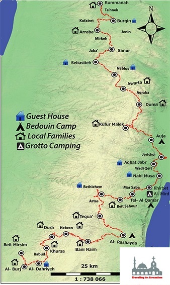
This stage extends from Sanur which is approximately 26 kms north of Jenin, to Sebastia which is located in the Nablus Governorate some 12 kilom
You start this hike by climbing the Mount Hraish which has an elevation of 650 meters and is located near Maythaloon town between Sanur and Sebastia.

While hiking on this mountain towards Sebastia, you will get to see the shrine that is located on the top of the mountain which traces back to ottoman period.

Info:
Walking Distance: Approximately 15.6 kms
Walking Time: Approximately 4 – 7 hours
Difficulty: Challenging

Recommendations:

  • Lightweight walkingboots
  • Walking poles
  • At least 3 – 4 liters of water and snacks for the hike
  • Sunscreen and a hat
  • Your camera

Accommodations in Sebastia:

  1. Al Kayed Guest-House
  2. Samer Al Shaer Guest-House
  3. Shadi Al Shaer Guest-Houseeters northwest of the city of Nablus.

Image Map


Traveling to Jerusalem

  •   4142 Adams St. Ste. 102-121 San Diego, CA 92116

  •    Mobile: (888) 768-6877

  •   Mail: info@travelingtojerusalem.com


Social Links


Palestine Gallery

p1a724agg71qk8shi1vg11k251pvlg p1a724agg61csf1ema1tkv1r12j73d 699A9784-W800 Abraham Path, section Sanur to Sebastia Abraham Path, section Sanur to Sebastia The Abraham Path. Hiking in the footsteps of the Patriarch

Contact Us

© Copyright 2016