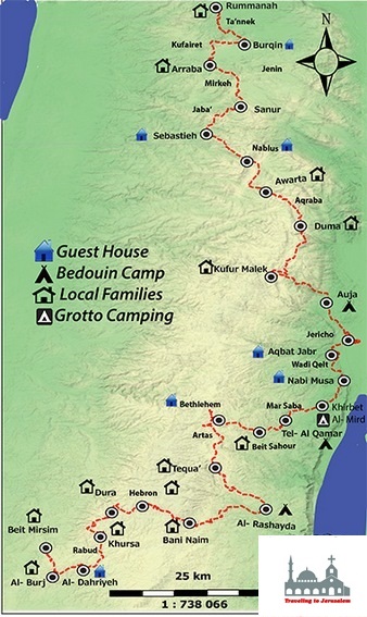
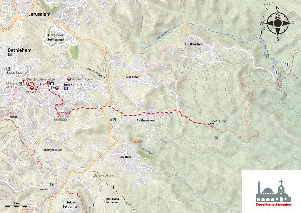


This hike starts from Tal Al-Qamar which is a Bedouin Camp Site located in the Jerusalem Wilderness between the Dead Sea and Bethlehem area, and is a part of the town of Dar Salah.
Masar Ibrahim passes through this site which you can visit right after passing the village of Nabi Musa near Jericho, and the wilderness near Mar Saba Monastery. Tal Al-Qamar is surrounded with dazzling view of green and brown mountain chain that extends all along the area around the Jerusalem Wilderness, giving you the chance to wander with your thoughts away from the urban bustle and its depressing and exhausting impact on the human body and spirit
After Tal Al-Qamar, you come to pass through the village of Al-Shawawra, which is located to the east of the city of Bethlehem, and is bordered by the wilderness lands from the east, Dar Salah from the north, Beit Sahour from the west, and Za’atara from the south. Right after passing Al-Shawawra, you reach Beit Bassa in the city of Beit Sahour where you will see the signage and panels of Masar Ibrahim, and from there, you keep walking through a valley called Hanna Saa’d Valley, up until you reach Beit Sahour downtown.
Beit Sahour is a city located at 1.5km (horizontal distance) east of Bethlehem, at an altitude of 650m above sea level. One of the religious and archeological sites of Beit Sahour that you pass from while walking on the Masar is Bir As-Sayidah – The Well of Mary: One of the deepest and most important wells that is located in the center of city. Jacob the son of Isaac (who was the son of Abraham) is believed to have dug this well. It is said that Virgin Mary, while traveling to Egypt, passed by it and since she was thirsty, she asked a woman if she would draw water for her. However, the woman refused and the water in the well miraculously overflowed by itself. This cistern is famous for the scene of many miracles, in addition to the site of a visitation by the Virgin Mary.
You then go up hill, reaching towards the city of Bethlehem in the north side of Bethlehem Governorate. Bethlehem has a long history that dates back to 1872. It was established and inhabited by the Canaanites around 2000 BC, and was called Beit Eilo Lahama, which means “house of the God Lahama,” who is the god of food and sustenance, according to the Canaanites, in connection with this name, the city’s name in Arabic indicates the meaning of food as well (house of meat). It is also worth noting that the meaning of the city name in the ancient Aramaic language is “The house of bread”.
Through walking the Masar in the Bethlehem area, you come to visit the Milk Grotto Church which is a serene grotto only a few minutes’ walk from Manger Square in Bethlehem. This grotto, with a Franciscan chapel built above it, is considered sacred because tradition has it that the Holy Family took refuge here during the Slaughter of the Innocents, before their flight into Egypt. Tradition has it that while Mary was nursing Jesus here, a drop of milk fell to the ground, turning it white. The irregularly shaped grotto is hollowed out of the soft white rock. A church was built here by the 5th century, and mosaic fragments on the terrace of the grotto, with geometrical motifs and crosses, are thought to belong to this time. Both Christians and Muslims believe scrapings from the stones in the grotto boost the quantity of a mother’s milk and enhance fertility. Mothers usually mix it in their drinking water; would be mothers place the rock under their mattress. There is also an old tradition that identifies this as the burial site of the young victims of Herod’s Slaughter of the Innocents. You finish this stage by reaching the Nativity Church and then having lunch at one of Bethlehem’s homestays.
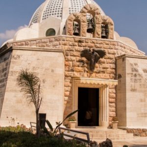
The Nativity Church was constructed by Constantine the Great (330AD), just above the cave or the grotto which is believed to be the stable where Jesus Christ was born. It is believed that this church is the oldest in the world. There is also another nearby cave where it is believed that Jerome spent thirty years of his life translating the Bible.
Info:
Walking Distance: Approximately 12 km
Walking Time: Approximately 3 – 4 hours
Difficulty: Easy
Recommendations:
Accommodations in Beit Sahour – Bethlehem: